Exploring New Frontiers with LiDAR Annotation
LiDAR in Environmental Conservation
One of the most promising applications of LiDAR annotation is in environmental conservation. By providing detailed maps of ecosystems, LiDAR helps scientists monitor changes in vegetation, track wildlife habitats, and study the effects of climate change. Annotated LiDAR data enables the creation of precise models of natural landscapes, which are crucial for conservation planning and management.
Infrastructure Maintenance and Monitoring
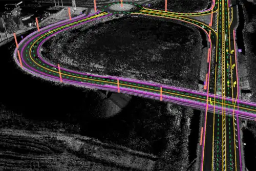
LiDAR annotation is increasingly being used for infrastructure maintenance and monitoring. By accurately mapping structures such as bridges, roads, and buildings, LiDAR helps identify potential issues before they become critical. Annotated data can highlight structural deformities, erosion, and other factors that require maintenance, thereby improving safety and reducing costs.
Archaeological Discoveries
LiDAR technology has made significant contributions to archaeology by uncovering hidden structures and artifacts. Annotated LiDAR data allows archaeologists to create detailed models of ancient sites, revealing information that traditional excavation methods might miss. This non-invasive approach preserves the integrity of archaeological sites while providing invaluable insights into historical civilizations.
Innovations and Advancements in LiDAR Annotation
Integration with Artificial Intelligence
The integration of AI with LiDAR annotation is transforming the field. AI algorithms can process vast amounts of LiDAR data quickly and accurately, identifying patterns and anomalies that might be missed by human annotators. Machine learning models are being trained to automatically annotate data, significantly speeding up the process and reducing costs.
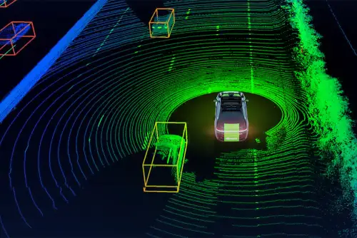
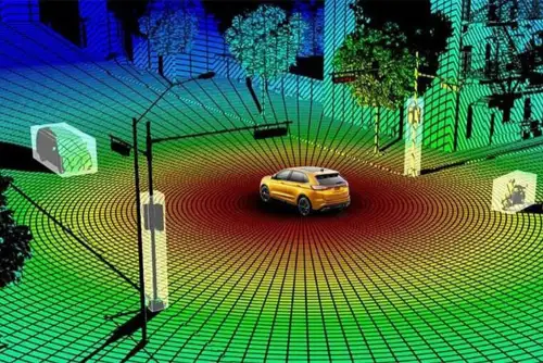
Real-time LiDAR Data Processing
Advancements in real-time data processing are enabling the immediate analysis of LiDAR data. This capability is particularly beneficial in dynamic environments such as autonomous vehicles and disaster response scenarios. Real-time annotation allows for instantaneous decision-making, enhancing the effectiveness of these applications.
Enhanced User Interfaces for Annotation Tools
The development of more intuitive and user-friendly interfaces for annotation tools is making it easier for annotators to work with complex LiDAR data. These interfaces often include features such as drag-and-drop labeling, customizable workflows, and interactive 3D visualization, which streamline the annotation process and improve accuracy.
Case Studies of LiDAR Annotation Success
Enhancing Urban Mobility in Smart Cities
In smart city projects, LiDAR annotation has played a crucial role in enhancing urban mobility. By mapping and analyzing traffic patterns, pedestrian movement, and public transportation usage, city planners can design more efficient and sustainable urban environments. Annotated LiDAR data helps in optimizing traffic flow, reducing congestion, and improving overall urban living conditions.
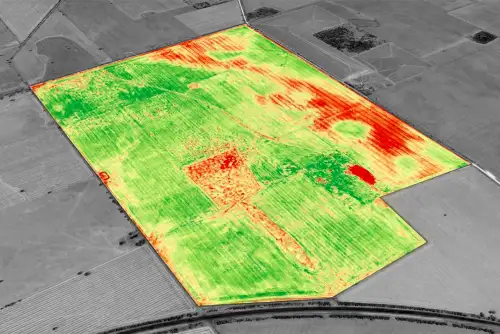
Precision Agriculture for Sustainable Farming
LiDAR annotation has revolutionized precision agriculture by providing detailed topographical and vegetation data. Farmers can use this information to optimize irrigation, monitor crop health, and manage land more effectively. Annotated LiDAR data supports sustainable farming practices by enabling precise resource allocation and minimizing environmental impact.
Renewable Energy Site Assessment
Renewable energy projects, particularly wind and solar farms, benefit from LiDAR annotation. By providing accurate terrain and surface data, annotated LiDAR helps in the optimal placement of turbines and solar panels, enhancing efficiency and energy production. This application is crucial for maximizing the output of renewable energy sources and reducing costs.
The Economic Impact of LiDAR Annotation
The economic benefits of LiDAR annotation are far-reaching. By improving the accuracy and efficiency of data interpretation, businesses can make better-informed decisions, reduce operational costs, and enhance productivity. Industries such as transportation, construction, and environmental management are seeing significant returns on investment from incorporating annotated LiDAR data into their operations.
Enhancing Safety and Security with LiDAR Annotation
Security Surveillance
LiDAR annotation is being used to enhance security surveillance systems. By creating detailed 3D maps of environments, LiDAR can help identify potential security threats and monitor large areas effectively. Annotated data is used to track movement patterns and detect anomalies, improving overall security measures.
Search and Rescue Operations
In search and rescue operations, annotated LiDAR data can be invaluable. It provides detailed terrain maps that aid in planning and executing rescue missions. The ability to quickly and accurately map disaster zones or remote areas can save lives by allowing rescue teams to navigate and operate more efficiently.
Environmental Impact Assessment
LiDAR annotation plays a critical role in environmental impact assessments. By providing precise topographical and land cover data, it helps in evaluating the potential effects of construction projects, mining activities, and other developments on the environment. Annotated LiDAR data supports the creation of detailed impact reports and the development of mitigation strategies.
Future Trends in LiDAR Annotation
Integration with Other Sensor Data
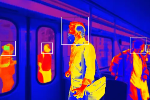
The future of LiDAR annotation lies in its integration with other sensor data, such as radar, sonar, and thermal imaging. Combining data from multiple sensors can provide a more comprehensive understanding of environments, enhancing the accuracy and applicability of annotated data.
Enhanced Machine Learning Models
As machine learning models continue to evolve, their ability to handle and process LiDAR data will improve. Future advancements will likely see more sophisticated models capable of performing complex annotations with minimal human intervention, further reducing costs and increasing efficiency.
Why Choose Subul Data Annotation for Your LiDAR Annotation Needs?
At Subul Data Annotation, we specialize in providing high-quality LiDAR annotation services tailored to your specific requirements. Our team of experts is equipped with the latest tools and techniques to deliver precise and reliable annotations.
Our Services Include:
- Custom Annotation Solutions: We offer customized annotation solutions to meet the unique needs of your project.
- Scalable Operations: Whether you have a small dataset or a large-scale project, we can scale our services to match your needs.
- Expert Team: Our annotators are highly trained and experienced in handling complex LiDAR data.
Contact Us Today!
Ready to enhance your LiDAR data with precise annotations? Contact Subul Data Annotation today to learn more about our services and how we can help you achieve your goals.