What is LiDAR and Why is Annotation Important?
LiDAR is a remote sensing method that uses light in the form of a pulsed laser to measure distances to the Earth. These light pulses, combined with other data recorded by the airborne system, generate precise, three-dimensional information about the shape of the Earth and its surface characteristics.
Annotation in the context of LiDAR data involves marking or labeling these three-dimensional points (point clouds) to help machine learning algorithms understand and interpret the data. High-quality annotation is critical for the development and refinement of technologies such as:
- Autonomous Vehicles: LiDAR helps self-driving cars detect and navigate around obstacles, pedestrians, and other vehicles.
- Robotics: Robots use LiDAR to map their surroundings and perform tasks with high precision.
- Drones: LiDAR enables drones to conduct topographic surveys, infrastructure inspections, and more.
The LiDAR Annotation Process
Our LiDAR annotation process is meticulous and detailed, ensuring that every point in a cloud is accurately labeled. Here’s an overview of how we approach LiDAR annotation:
- Data Collection: We start by gathering high-resolution LiDAR data, which can come from various sources such as drones, autonomous vehicles, or stationary LiDAR systems.
- Preprocessing: The collected data often requires preprocessing to remove noise and ensure clarity. This step involves filtering out irrelevant points and enhancing the quality of the data.
- Annotation: Our team of skilled annotators uses advanced tools and software to label the data. This involves identifying objects within the point cloud, such as vehicles, pedestrians, buildings, and natural features, and marking them with high precision.
- Quality Assurance: We implement rigorous quality control measures to verify the accuracy of our annotations. This step ensures that the annotated data meets the specific requirements of our clients.
- Delivery: Once the annotation and quality assurance processes are complete, we deliver the annotated data to our clients in the required format.
Applications of LiDAR Annotation
The applications of LiDAR annotation are vast and varied, making it an indispensable tool across multiple industries:
- Autonomous Driving: Enhances the vehicle’s ability to recognize and react to its environment, improving safety and efficiency.
- Urban Planning: Assists in creating detailed 3D maps for urban development and infrastructure projects.
- Forestry and Agriculture: Helps in monitoring vegetation health, estimating biomass, and managing agricultural lands.
- Environmental Monitoring: Facilitates the study of natural landscapes, tracking changes over time due to natural disasters or human activities.
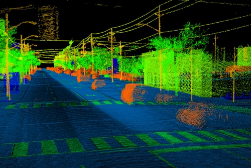
Types of LiDAR Annotation
Understanding the various types of LiDAR annotation is crucial for selecting the right approach for your project. At Subul Data Annotation, we offer several types of LiDAR annotation services, each tailored to specific applications:
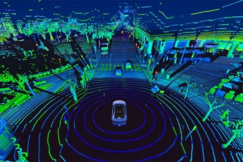
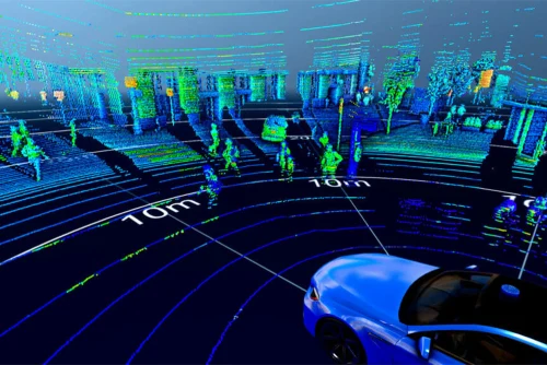
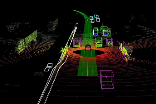
- 3D Bounding Boxes: Used to encapsulate objects within a 3D space, allowing for accurate object detection and tracking in applications such as autonomous driving.
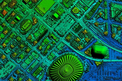
- Semantic Segmentation: This involves labeling each point in the point cloud with a class, such as ‘road’, ‘vegetation’, or ‘building’, to create detailed maps.
- Instance Segmentation: Similar to semantic segmentation, but with the added complexity of distinguishing between multiple instances of the same class, such as differentiating between two adjacent trees.
- Polyline Annotation: Used for marking lanes, roads, and other linear features, crucial for navigation and mapping purposes.
Challenges in LiDAR Annotation
While LiDAR technology offers tremendous benefits, the annotation process is not without its challenges:
- High Volume of Data: LiDAR sensors generate massive amounts of data, requiring efficient processing and storage solutions.
- Complexity of Data: The three-dimensional nature of LiDAR data makes it more complex to annotate compared to two-dimensional images.
- Need for Precision: Even small errors in annotation can lead to significant issues in downstream applications, necessitating extremely high precision.
- Dynamic Environments: In applications like autonomous driving, the environment is constantly changing, requiring real-time annotation and updating of data.
Our Approach to Overcoming Challenges

At Subul Data Annotation, we have developed robust strategies to address these challenges effectively:
- Advanced Tools and Software: We leverage state-of-the-art tools and software that can handle large volumes of data efficiently.
- Skilled Annotators: Our team comprises highly trained professionals who understand the intricacies of LiDAR data and can annotate it with great precision.
- Quality Control: We implement multi-level quality checks to ensure the highest level of accuracy in our annotations.
- Customization: We tailor our services to meet the unique needs of each client, providing solutions that are both effective and scalable.
Case Studies: Success Stories with LiDAR Annotation
Our expertise in LiDAR annotation has led to numerous success stories across various industries:
- Autonomous Vehicle Development: We collaborated with a leading autonomous vehicle company to annotate LiDAR data for their fleet. Our precise annotations helped improve the vehicle’s object detection and navigation capabilities, significantly enhancing safety.
- Urban Planning Projects: In partnership with a major urban planning firm, we provided detailed annotations of cityscapes, aiding in the development of more efficient and sustainable urban infrastructures.
- Environmental Monitoring: Our work with an environmental agency involved annotating LiDAR data for forested areas, which helped in monitoring deforestation and managing natural resources more effectively.
Future Trends in LiDAR Annotation
The future of LiDAR annotation looks promising, with several trends set to shape the industry:
- Integration with AI: Combining LiDAR annotation with artificial intelligence can lead to more accurate and efficient data processing.
- Real-time Annotation: Advances in technology are making real-time annotation more feasible, particularly for dynamic environments like autonomous driving.
- Enhanced Tools and Techniques: Continuous development of new tools and techniques will further improve the accuracy and efficiency of LiDAR annotation.
Why Choose Subul Data Annotation for LiDAR Annotation Services?

At Subul Data Annotation, we pride ourselves on delivering exceptional LiDAR annotation services that stand out in terms of quality and accuracy. Here’s why you should choose us:
- Expert Team: Our annotators are highly trained and experienced in handling complex LiDAR datasets.
- Cutting-edge Technology: We use the latest annotation tools and software to ensure precision.
- Scalability: Whether you have a small project or a large-scale requirement, we have the capacity to deliver timely results.
- Customized Solutions: We tailor our services to meet the specific needs of each client, ensuring satisfaction and success.
- Competitive Pricing: Our services are competitively priced to offer you the best value for your investment.
Get Started with Subul Data Annotation Today!
If you’re looking for top-notch LiDAR annotation services that guarantee accuracy and reliability, look no further than Subul Data Annotation. Our expert team is ready to help you enhance your projects with high-quality annotated data. Contact us today to learn more about our services and how we can assist you in achieving your goals.