Delving into Geospatial Annotation: The Art of Data Enrichment
Geospatial annotation is the meticulous process of enriching geospatial data by meticulously adding labels and detailed descriptions to specific features within the data. These features can encompass anything from the intricate details of buildings and road networks to the vast expanse of different vegetation types and land-use patterns. Through manual annotation, human annotators essentially become data whisperers, training AI and machine learning models to “see” and interpret the real world reflected in the geospatial imagery.
Why Geospatial Annotation is the Unsung Hero of Data Analysis
The importance of geospatial annotation in unlocking the value of geospatial data cannot be overstated. Here’s a deeper dive into the compelling reasons why it’s crucial:
- Sharpened Accuracy: Precise annotation empowers AI models to identify and classify objects within geospatial data with unparalleled accuracy. This enhanced precision is the backbone for groundbreaking applications like autonomous vehicles, environmental monitoring initiatives, and meticulous urban planning efforts.
- Context is King: Annotations breathe life into the data by providing crucial context. AI models, armed with this enriched understanding, can decipher the relationships between various features. This newfound knowledge is vital for tasks like in-depth land cover analysis, efficient infrastructure management, and resourceful resource exploration.
- Customization is Key: The beauty of geospatial annotation lies in its adaptability. Businesses can tailor their annotation projects to their specific needs. Depending on their unique goals, they can choose to annotate data for object detection, scene classification, or change detection, making the data truly work for them.
The Vast Landscape of Geospatial Annotation Applications
Geospatial annotation transcends industry boundaries, finding application in a multitude of fields:
- Autonomous Vehicles: Highly accurate annotations are the invisible teachers that train self-driving cars to recognize pedestrians, navigate traffic signs, and stay within designated lanes.
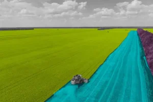
- Agriculture: With the power of annotation, farmers can classify crop types with ease, monitor crop health with precision, and assess yield potential to optimize their harvests.
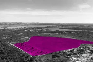
- Environmental Monitoring: Annotations become the watchful eyes that enable us to track deforestation, analyze land degradation, and monitor natural disasters, allowing for proactive environmental protection.
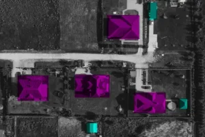
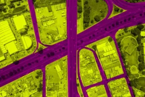
- Urban Planning: Annotations act as a detailed map, aiding in the meticulous planning of infrastructure, assessment of building types, and analysis of urban sprawl, fostering the creation of sustainable and efficient cities.
Subul Data Annotation: Your Trusted Partner in Geospatial Annotation Expertise
At Subul Data Annotation, we recognize the critical role geospatial annotation plays in unlocking the power of location-based data. We boast a team of highly skilled and experienced human annotators who are adept at handling even the most complex geospatial annotation projects with unparalleled accuracy and efficiency. We leverage cutting-edge annotation tools and employ rigorous quality control processes to ensure the highest possible data quality, providing you with data that is as reliable as it is insightful.
Ready to Unleash the Secrets Hidden in Your Geospatial Data?

If you’re eager to extract valuable insights from your geospatial data and propel your business forward, Subul Data Annotation is the perfect partner for you. We are here to help you unlock the hidden potential within your location data. Contact us today to discuss your specific needs and learn how our comprehensive geospatial annotation services can empower you to achieve your goals.